Current Views: 122421
 Current Downloads: 74807
Environment and Resource
ISSN Print:2707-2398
ISSN Online:2707-2401
Contact Editorial Office



Subscribe to the latest published information from SCISCAN
Stratigraphic and Sedimentary Characteristics of the Fourth Member of the Shahejie Formation in the Western Sag of the Liaohe Depression


-
Information:
1. Liaohe Oilfield, CNPC, Panjin, Liaoning;
2. College of Petroleum Engineering, Liaoning Petrochemical University, Fushun, Liaoning;
3. Research Institute of Exploration and Development, Qinghai Oilfield, CNPC, Dunhuang, Gansu
-
Keywords:
Liaohe depression; Western sag; Fourth Member of Shahejie Formation; Cyclostratigraphy; eccentricity; Sedimentary facies evolution; Well correlation
- Abstract: The Fourth Member of the Shahejie Formation in the Leijia area, Western Sag, Liaohe Depression, was deposited against a background of intense tectonic activity during the early rifting stage. The sedimentary system was controlled by a combination of differential subsidence of boundary faults, sediment supply, and lakelevel– climate fluctuations, making stratigraphic surface identification and facies belt tracking challenging. This study integrates core and sidewall core, mud logging, and conventional wireline logging data to: (1) clarify the identification characteristics of the top and bottom boundaries of the Fourth Member and establish three sets of regional correlation marker beds; (2) conduct eccentricity-scale cyclostratigraphic analysis based on logging curves from 37 wells, identify stable 405 kyr long eccentricity signals and distinct short-period responses, and construct a fine correlation framework of fourth-order sequences (sq1–sq6) and sublayers (c1–c13); and (3) within this framework, discriminate sedimentary facies and microfacies by integrating core sedimentary structures, lithological associations, and logging responses, and determine the spatiotemporal migration patterns of the sedimentary system through representative well facies sequence analysis and multi-well cross-section correlation. Results show that: the bottom boundary of the Fourth Member exhibits a clear electrical contrast with the underlying Fangshenpao Formation, whereas the top boundary in the sag center requires constraint by marker beds and well-to-well tracking; lacustrine facies dominate, followed by fan-delta facies, with delta facies locally developed in the western gentle slope belt and sublacustrine turbidite fan deposits identifiable within the lake basin; within the sequence framework, facies belt migration shows staged evolution—early stages were strongly controlled by paleogeomorphology and differential subsidence, deep-lake fine-grained deposits dominated at the basin scale during the maximum lake flooding period, followed by a relative regression stage with enhanced progradation and lateral compensation with deep-water fine-grained deposits, and late-stage re-deepening led to re-expansion of deep-lake deposits. Integrating the tectonic framework and sedimentary responses, we establish an asymmetric sedimentary facies model for the Fourth Member characterized by “proximal fan-delta clastic input along the eastern steep slope / delta and shallow-lacustrine deposits along the western gentle slope / semideep to deep-lacustrine fine-grained deposits in the basin center.”
- DOI: 10.35534/er.0802040
- Cite: Li, Y., Lai, P., Zhou, X. L., Huang, Y. L. (2026). Stratigraphic and Sedimentary Characteristics of the Fourth Member of the Shahejie Formation in the Western Sag of the Liaohe Depression. Environment and Resource, 8(2), 299-313.
In recent years, fine-grained sedimentary systems in rift lacustrine basins have received continuous attention in shale oil and tight oil exploration(Cao et al. 2023). Compared with marine shales, fine-grained lacustrine deposits in continental basins are characterized by multiple sediment sources, mixed mineral compositions, rapid lateral lithological changes, and strong heterogeneity. The sedimentary filling process is jointly controlled by fault activity, sediment supply, and climate–lake-level fluctuations, significantly increasing the difficulty of stratigraphic correlation and facies belt tracking(Fischer et al. 2004; Schwarzacher 1993).
The Fourth Member of the Shahejie Formation in the Western Sag, Bohai Bay Basin, was formed during a period of intense tectonic activity in the early rifting stage. It represents an important interval for deep-water fine-grained sedimentation, with superimposed influences from proximal fan-delta clastic input, episodic enhancement of carbonate deposition, and volcanic activity, resulting in pronounced asymmetry and staged evolution of the sedimentary system.
The Fourth Member in the Leijia area is representative of oil and gas exploration and sedimentological studies. Previous studies have achieved systematic understanding of the sedimentary environment, the origin of carbonate rocks and analcime, and their relationship with volcanic–hydrothermal activity. However, at the regional correlation scale, a unified framework is still lacking for: (1) stable identification of the top and bottom boundaries of the Fourth Member, (2) the constraining role of regional marker beds, and (3) a time-constrained fine sequence framework. Meanwhile, the spatiotemporal migration patterns of sedimentary facies belts within the sequence framework and their controlling factors still need to be further clarified under multi-well correlation constraints, which directly limits the detailed characterization and regional correlation interpretation of fine-grained sedimentary filling processes in rift lacustrine basins.
To address these issues, this study integrates core and sidewall core observations, mud logging data, conventional logging curves (mainly GR and resistivity), and related analytical test results. We first identify the top and bottom boundaries of the Fourth Member based on lithological–electrical contrast characteristics and establish three sets of regional correlation marker beds to improve the reliability of horizon picking and inter-well tracking. Subsequently, we conduct eccentricity-scale cyclostratigraphic analysis based on logging curves from 37 wells, identify 405 kyr long eccentricity and short-period signals, and construct a fine correlation framework of fourth-order sequences (sq1–sq6) and sublayers (c1–c13). On this basis, we discriminate sedimentary facies and microfacies by integrating core sedimentary structures and lithological associations, use logging responses for lateral extension, conduct representative well facies sequence analysis and multi-well cross-section correlation, and summarize the sedimentary facies model and main controlling factors of the Fourth Member, thereby providing a geological basis for fine correlation and sedimentary evolution studies of fine-grained sedimentary systems in rift lacustrine basins.
1 Geological Settings
Since the discovery of carbonate hydrocarbon reservoirs in the Fourth Member of the Shahejie Formation in the Leijia area in the 1990s, exploration targets have progressively shifted from conventional reservoirs to tight oil and shale oil with advancing exploration and development.
The Liaohe Depression is located in the northeastern part of the Bohai Bay Basin(Liang et al. 1992; The Liaohe and Gas Province Compilation 2022). It is a multi-cycle Cenozoic continental rift basin formed on the North China Platform basement under Meso–Cenozoic regional extensional tectonism, exhibiting an overall “three uplifts–three sags” structural configuration. The Western Sag is the largest secondary negative structural unit within the Liaohe Depression, trending NE. Its structural style is characterized as a narrow, half-graben–type fault depression with east-faulted and west-overlapped geometry (steep in the east and gentle in the west). The Leijia area is located in the north-central part of the Western Sag and includes two secondary sub-sags: the Chenjia and Taian sub-sags.
During the deposition of the Fourth Member, the lake basin pattern was significantly controlled by fault activity and differential subsidence(The Liaohe and Gas Province Compilation 2022). Taking the Du-3 depositional period as an example, the sedimentary system was dominated by semi-deep to deep lacustrine subfacies, with delta and fan-delta systems commonly developed along the basin margins. The rock compositions are complex, with fine-grained sediments mainly composed of clay minerals, felsic minerals, carbonates, and analcime. Lamination structures and deformation structures such as convolute bedding are common. Affected by both mineral assemblages and tectonic activity, the rocks are overall relatively brittle, with well-developed fractures and dissolution pores, and generally favorable hydrocarbon shows, thus providing an important geological basis for tight oil and shale oil exploration in this area.
2 Stratigraphic Characteristics
2.1 Top and Bottom Boundaries of the Fourth Member
In the Leijia area, the Fourth Member of the Shahejie Formation is in conformable contact with the overlying Third Member in the main sag area, with local disconformities at the margins. It is mostly in disconformable or angular unconformable contact with the underlying Fangshenpao Formation. Overall, the bottom boundary of the Fourth Member is relatively clear to identify, whereas the top boundary in the sag center is often difficult to precisely locate and typically requires constraint by regional marker beds and lateral tracking.
In the sag center, both the top of the Fourth Member and the bottom of the Third Member are dominated by deep-water fine-grained sediments with weak lithological and electrical differences. The top of the Fourth Member is mostly dark gray to gray calcareous mudstone, while the bottom of the Third Member is dominated by dark gray to gray mudstone with local interbeds of grayish-brown oil shale. On well logs, the GR at the top of the Fourth Member is mostly 80–100 API (mean ~90 API) with slightly serrated resistivity, while the GR at the bottom of the Third Member is relatively higher (90–120 API, mean ~110 API) with straighter and slightly lower resistivity values. Therefore, under single-well conditions, this boundary often needs to be constrained by combining regional correlation marker beds and well-to-well tracking (e.g., Well L93).
In the marginal belt of the sag, influenced by the fan-delta–delta system, the Es3/Es4 boundary is relatively easier to identify. In the eastern steep slope belt, the sand content at the top of the Fourth Member increases, and GR often decreases (~40–80 API). The lower part of the Third Member develops fan-delta front sandy conglomerates, and GR tends to show a typical funnel-shaped combination (e.g., Well L62). In the western gentle slope belt, fluvial-delta deposits at the top of the Fourth Member are locally visible, and the top of the Fourth Member may be sandy conglomerates or interbedded sandy conglomerates and mudstones. In some well areas affected by uplift and erosion, the Guantao Formation directly overlies the Fourth Member.
The identification of the bottom boundary of the Fourth Member and the Fangshenpao Formation is mainly based on significant lithological and electrical contrast. The Fangshenpao Formation is dominated by basalt (with tuff as secondary), with dense and hard rocks and obviously low GR values on well logs (10–40 API, mean ~30 API), forming a clear boundary with the medium-to-high GR response of the overlying fine-grained sedimentary rocks of the Fourth Member. The lithology of the basal cover of the Fourth Member varies with location and may be thick mudstone (eastern steep slope belt and Shuguang area), grayish-green thin mudstone, granular carbonate rocks, or locally argillaceous siltstone/argillaceous conglomerate, with basalt interlayers visible in some wells (e.g., Well L15). Despite differences in the lithological assemblage at the base, the bottom boundary overall shows a transition from low GR of volcanic rocks to higher GR of sedimentary rocks, making it easy to correlate uniformly in most wells (Fig.1).
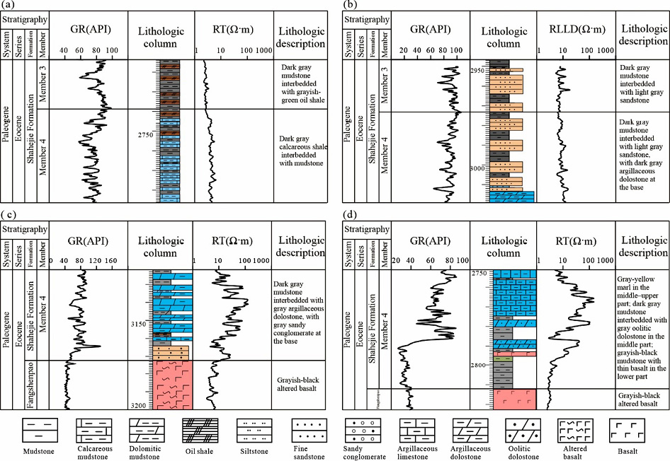
Figure 1 Stratigraphic top and bottom characteristics of the Fourth Member
Note: (a) Well L93; (b) Well L62; (c) Well Gaogu 15; (d) Well L15
2.2 Stratigraphic Correlation Marker Beds
To improve the reliability of horizon picking and inter-well correlation of the Fourth Member, three sets of regional correlation marker beds were identified in the study area (Fig. 2).
A relatively stable carbonate rock layer is developed in the lower part of the Fourth Member. In the semi-deep to deep lake area, it is dominated by brownish-gray to brownish-yellow argillaceous carbonate rocks, while in the underwater uplift area, it is mostly gray to grayish-green medium-to-thick-bedded granular limestone. It gradually thins toward the basin margin and changes to gray to grayish-green mudstone interbedded with fine sandstone. This layer is widely developed throughout the area with only thickness variations and is an important regional correlation bed.
A set of gray to dark gray mudstone or grayish-brown oil shale (“mud neck” layer) is widely developed above the Gaosheng oil layer. This layer is continuous and stable, representing the sedimentary deposits of the maximum lake flooding period of the Fourth Member, and is a key marker bed for regional correlation.
A set of analcime-bearing argillaceous carbonate rock layer is developed in the middle of the Fourth Member, dominated by argillaceous dolomite/argillaceous carbonate rocks containing certain analcime minerals, mainly concentrated in the Du-3 oil layer, with the L29-15 area as the center, and carbonate and analcime content decreasing outward. In the L93 area, it may change to carbonate mudstone, and in the S112 area, it may appear as interbedded sandstone and mudstone. The logging response of this layer usually shows a high GR–high resistivity combination with good regional correlation.
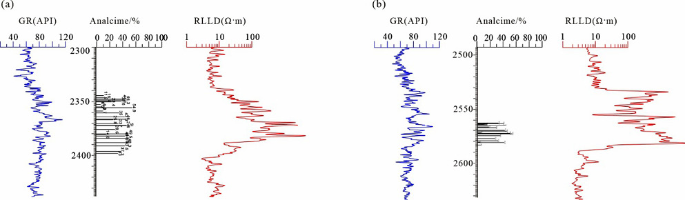
Figure 2 Electric logging curve characteristics of the analcime-developed interval
Note: (a) Well L57; (b) Well L36
2.3 Eccentricity-Scale Fine Stratigraphic Division and Correlation
To introduce time constraints into the regional correlation framework, this study adopts eccentricity-scale cyclostratigraphy for fine division(Berger 1988; Fischer et al. 2004; Schwarzacher 1993). It is generally believed that fourth-order sequences are closely related to the 405 kyr long eccentricity cycle (and its modulation cycle), while fifth-order sequences correspond to the short eccentricity scale(Laskar et al. 2011; Laskar et al. 2004; Meyers 2015).
In the Fourth Member of the Leijia area, a significant 405 kyr long eccentricity signal was identified, along with relatively clear ~129 kyr short eccentricity signals (the ~100 kyr signal is relatively weak)(Meyers and Sageman 2007). Accordingly, the Fourth Member can be divided into 6 long eccentricity cycles (fourth-order sequences), and approximately 17 short eccentricity cycles (fifth-order sequences) were further identified on the ~129 kyr filtering results. This result is comparable to the understanding of “six sets of fourth-order sequences” in the same interval of other sags in the Bohai Bay Basin, indicating that eccentricity-scale cyclostratigraphy has good applicability in this area(Jin et al. 2022)Bohai Bay Basin</title><secondary-title>Palaeogeography, Palaeoclimatology, Palaeoecology</secondary-title></titles><periodical><full-title>Palaeogeography, Palaeoclimatology, Palaeoecology</full-title></periodical><pages>110740</pages><volume>585</volume><dates><year>2022</year></dates><urls></urls></record></Cite></EndNote>.
Combining the cyclostratigraphic identification results from 37 exploration wells in the study area, this study divides the Fourth Member into 6 fourth-order sequences (sq1–sq6) and further subdivides them into 12 sublayers (c1–c12) based on the maximum points of each fourth-order sequence(Li, Hinnov, and Kump 2019). To ensure top correlation continuity, a half-cycle c13 is added at the top of the Fourth Member, forming a continuous fine correlation framework (Fig. 3)(Kodama and Hinnov 2014).
According to the oilfield oil layer classification system, the Gaosheng oil layer corresponds to sq1–sq3 (c1–c6), and the Dujiatai oil layer corresponds to sq4–sq6. Among them, the Du-3 oil layer corresponds to c7–c9, the Du-2 oil layer corresponds to c10–c12, and the Du-1 oil layer corresponds to c13.
Under the constraint of this framework, more than 30 wells were selected for lateral correlation. A well correlation cross-section was drawn with the top of c12 leveled, and isopach maps of sq1–sq6 were compiled (Figure 5a–5d) to depict the spatiotemporal distribution and subsidence pattern of the Fourth Member. Comprehensive results show that early subsidence differences were significant, with an overall pattern of thick in the east and thin in the west, thick in the south and thin in the north(Boulila et al. 2014; Boulila et al. 2018)Slah</author><author>Laskar, Jacques</author><author>Haq, Bilal U.</author><author>Galbrun, Bruno</author><author>Hara, Nathan</author></authors></contributors><titles><title>Long-term cyclicities in Phanerozoic sea-level sedimentary record and their potential drivers</title><secondary-title>Global and Planetary Change</secondary-title></titles><periodical><full-title>Global and Planetary Change</full-title></periodical><pages>128-136</pages><volume>165</volume><dates><year>2018</year></dates><urls></urls></record></Cite></EndNote>. The subsidence center was close to the eastern steep slope belt and generally distributed along the NE direction. From sq1 to sq6, the thickness pattern had certain inheritance, but with deepening water, the scope of underwater uplifts gradually decreased. After the sq3 maximum lake flooding period, thickness undulations tended to flatten, reflecting the basin evolution process of continuous filling of the Fourth Member from bottom to top. The distribution of the sedimentary system and facies belt migration characteristics under the constraint of this stratigraphic framework will be further discussed in Chapter 3.
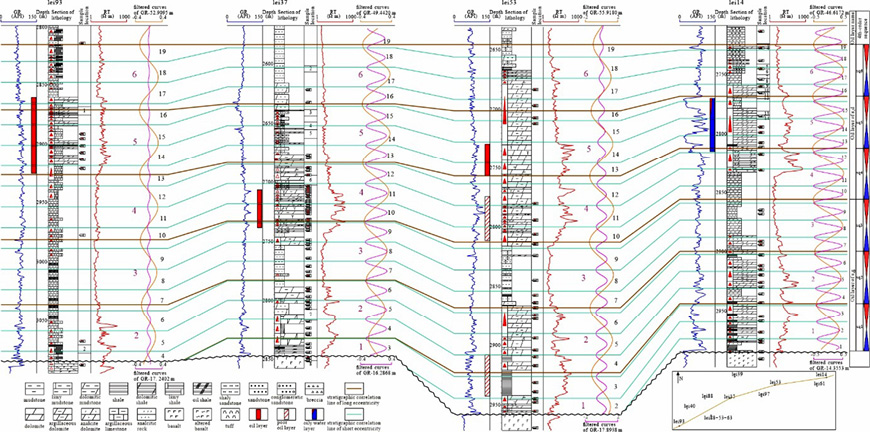
Figure 3 Eccentricity-scale fine stratigraphic division and correlation
Note: Blue curve: GR curve in depth domain; Red curve: resistivity curve in depth domain; Orange-red curve: filtered long eccentricity curve of GR in depth domain; Magenta curve: filtered short eccentricity curve of GR in depth domain; Brown line: stratigraphic correlation line of long eccentricity; Cyan line: stratigraphic correlation line of short eccentricity.
3 Sedimentary Characteristics
3.1 Development Characteristics of Sedimentary Rocks
Under the constraint of the sequence–sublayer framework established in Chapter 2, the sedimentary system of the Fourth Member is dominated by lacustrine mixed fine-grained sediments with complex mineral compositions, mainly composed of carbonates, felsic minerals, clay minerals, and analcime, often accompanied by authigenic minerals such as pyrite(Cao et al. 2023). Various fine-grained components mostly coexist in mixed forms, lamination structures are commonly developed, and deformation structures such as convolute bedding and slumping are frequently observed, indicating rapid fluctuations in the lake basin environment and strong heterogeneity of the sedimentary process(Anderson and Dean 1988; Baars et al. 2023).
In section, dark laminated mudstone (mud shale) dominates, followed by carbonate rocks and sandy conglomerates, with local occurrences of analcime rock types. Volcanic materials are only minorly intercalated within the Fourth Member, overall showing a lacustrine sedimentary assemblage under the background of early rifting volcanic activity.
In plane view, sediments generally show a zoning pattern of “coarse in the east, fine in the west, deep water in the center”: the eastern steep slope belt has strong proximal clastic input, the western gentle slope belt has relatively insufficient clastic supply, and the sag center is dominated by semi-deep to deep lacustrine fine-grained sediments (Figure 4).
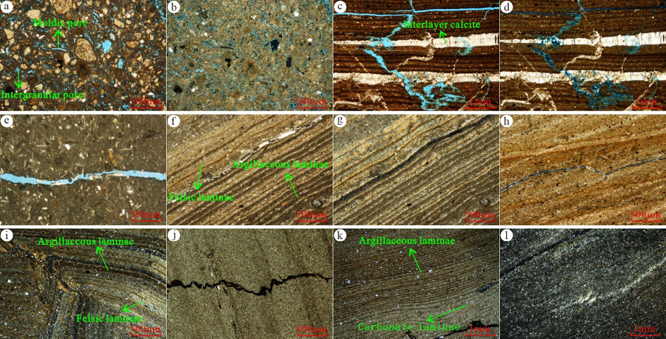
Figure 4 Microscopic characteristics of sedimentary rocks in c1–c4 layers (Gaosheng oil layer)
Note: (a) Granular dolomite with bioclasts, intergranular pores and moldic pores developed, Well L86, 1656.7 m, cast thin section, (−); (b) Same as (a), (+); (c) Laminated argillaceous dolomite with multi-stage fractures developed, calcite developed along bedding, Well L36, 2690.71 m, cast thin section, (−); (d) Same as (c), (+); (e) Granular dolomite with bioclasts, fractures unfilled, Well L84, 2778.27 m, cast thin section, (−); (f) Mud shale with felsic laminae and argillaceous laminae containing dolomite, and interlayer fractures visible, Well L84, 2779.12 m, ordinary thin section, (−); (g) Same as (f), (+); (h) Argillaceous dolomite with interbedded argillaceous laminae and dolomite laminae, fractures developed, Well L37, 2815.5 m, cast thin section, (−); (i) Mud shale with interbedded argillaceous laminae and felsic laminae, deformation structures visible, Well L97, 3280 m, ordinary thin section, (+); (j) Argillaceous dolomite, pressure solution seam, Well L97, 3278 m, ordinary thin section, (+); (k) Argillaceous siltstone, Well L99, 3452 m, ordinary thin section, (+); (l) Argillaceous siltstone, Well L99, 3461 m, ordinary thin section, (+)
3.2 Sedimentary Facies Types and Characteristics
Integrating detailed core observations, mud logging and logging responses, combined with regional geological data and previous understanding, the Fourth Member is dominated by lacustrine facies sedimentation, followed by fan-delta facies, with delta facies locally developed in the western gentle slope belt, and sublacustrine turbidite fan deposits identifiable within the lake basin.
Lacustrine facies can be divided into two subfacies: shallow lacustrine and semi-deep to deep lacustrine. The shallow lacustrine subfacies mainly includes microfacies such as sandy beach bar, granular beach, inter-beach, and muddy shallow lake. The semi-deep to deep lacustrine subfacies mainly includes muddy lake bottom and a series of lake bottom microfacies mixed with dolomitic/calcareous components.
Fan-delta facies consist of fan-delta plain, fan-delta front, and pro-fan-delta. Delta facies consist of delta plain, delta front, and pro-delta. This facies–microfacies system provides a unified discrimination framework for single-well facies sequence identification and multi-well correlation.
3.3 Single-Well Facies Analysis
Under the facies–microfacies framework, this study conducted fine division and vertical evolution analysis of single-well sedimentary facies for most wells in the study area, and selected Wells L86 and L93 as representatives (Figure 5–6).
Well L86 is overall shallow lacustrine subfacies sedimentation, showing an evolution from relatively shallow water to deeper water environments from bottom to top, though with a return to shallower conditions at the very top. For instance, at the top (c11–c12 sublayers), inter-beach microfacies appear, with lithology dominated by micritic dolomitic limestone (Figure 5), reflecting a localized shallowing trend consistent with the regional regression phase.
Well L93 is located in the center of the Chenjia sub-sag. Shallow-water sedimentation in the early stage of the Fourth Member is not developed, and the deep-lake environment dominates vertically. Lamination structures of fine-grained sediments are commonly developed, with local deformation structures such as convolute bedding visible, and favorable hydrocarbon shows. During c3–c8, the muddy lake bottom microfacies dominated, with lithology mainly mudstone and oil shale, and local cyclic superposition of calcareous muddy lake bottom and muddy lake bottom visible. During c9–c11, the dolomitic component increased, forming uneven interbeds of argillaceous dolomite and dolomitic mudstone, showing alternating development of muddy-dolomitic lake bottom and dolomitic-muddy lake bottom microfacies. During c12–c13, terrigenous clastic input enhanced and water depth increased, and the lithology was again dominated by mud shale and oil shale, with the sedimentary environment returning to muddy lake bottom microfacies (Figure 6).
The above single-well facies sequence characteristics provide typical constraints for facies belt migration and basin-scale correlation.
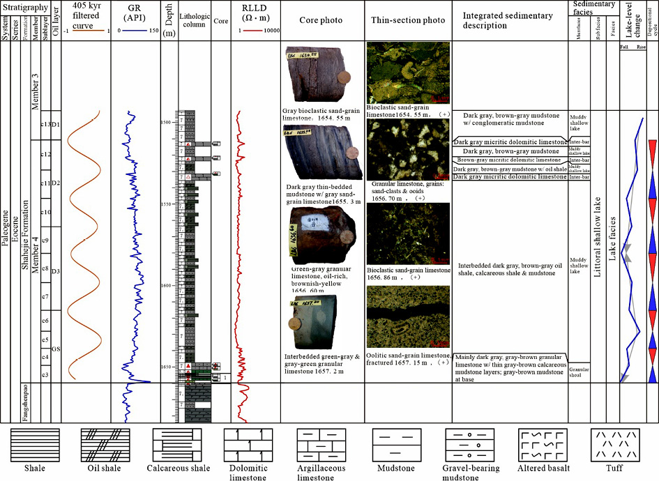
Figure 5 Comprehensive sedimentary facies column of Well L86
3.4 Vertical and Lateral Correlation Analysis of Sedimentary Facies
To reveal the vertical and lateral distribution patterns of sedimentary facies of the Fourth Member within the sequence framework, based on single-well analysis and integrating core, logging, and test analysis data, and introducing the eccentricity-scale fine correlation framework established in Chapter 2, multi-well sedimentary facies lateral correlation was conducted within the sq1–sq6 sequence framework.
Based on well location distribution and basin distribution direction, two well correlation facies cross-sections were compiled: one along the long axis of the lake basin (S112–L93–L88-H501 directional well–L37–L97–L53–L14), and the other along the short axis of the lake basin (L86–L40–L93–L99–L88-59-85–L111–S150)(Figure 7).
Both cross-sections indicate that the sedimentary evolution of the Fourth Member shows staged characteristics: early facies belts were significantly controlled by paleogeomorphology and sediment sources, with obvious differentiation between shallow lacustrine–fan-delta systems and deep-lake fine-grained sediments. By the sq3 maximum lake flooding period, the deep-water scope expanded, and the deep-lake muddy lake bottom microfacies dominated at the basin scale. Subsequently, upon entering a relative regression stage, facies belts underwent systematic migration at the basin scale, with carbonate deposition and clastic input showing obvious compensation. During late-stage re-deepening, fine-grained deep-water sediments again became dominant.
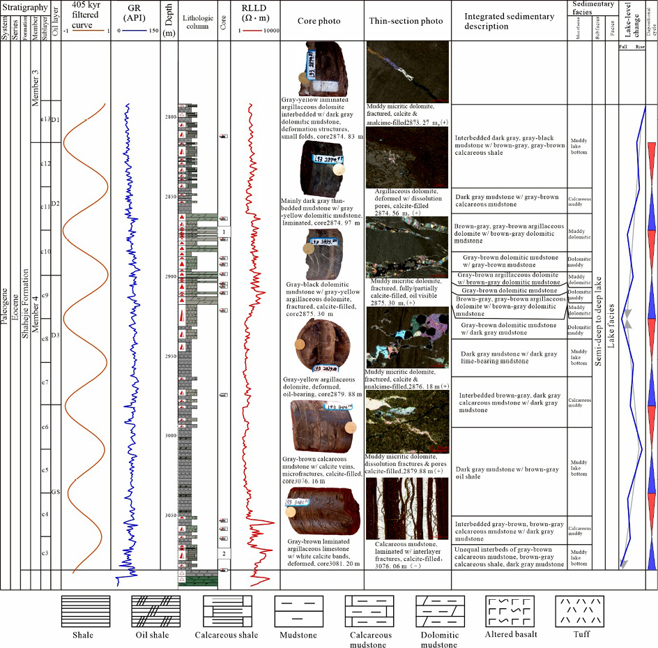
Figure 6 Comprehensive sedimentary facies column of Well L93
The comparison results also show that fan-delta sand bodies in the eastern steep slope belt and semi-deep to deep-lacustrine fine-grained sediments have significant lateral squeezing relationships, while carbonate deposits are generally more stable along the long axis of the lake basin and form relatively concentrated sedimentary centers in local well areas. The above characteristics provide a direct basis for establishing the sedimentary facies model of the Fourth Member.
3.5 Sedimentary Facies Model
Integrating well correlation results and the tectonic–paleogeomorphological background, during the deposition of the Fourth Member, the Western Sag was a typical single-faulted half-graben basin with east-faulted and west-overlapped geometry. The basin morphology was strongly asymmetric, overall showing a tectonic–geomorphological pattern of high in the west and low in the east, steep in the east and gentle in the west. This pattern, together with the syn-sedimentary activity of boundary faults, controlled the sediment supply mode and sedimentary system configuration, thereby determining the spatial differentiation of sedimentary facies belts.
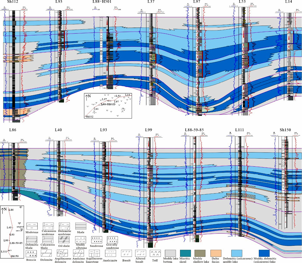
Figure 7 Well correlation facies cross-section
Note: (a) S112–L93–L88-H501 directional well–L37–L97–L53–L14; (b) L86–L40–L93–L99–L88-59-85–L111–S150
The eastern steep slope belt was affected by the Taian–Dawa fault and its strong hanging wall drop, resulting in large topographic relief. Coarse clastic materials from the Central Uplift rapidly entered the lake along the slope and formed a stable fan-delta distribution belt, with thick sand and conglomerate interbedded with mudstone as the main lithological assemblage. Strong terrigenous clastic dilution limited lacustrine carbonate deposition in this area(Figure 8).
The western gentle slope belt transitions from a gentle slope to the Western Uplift. The sedimentary system is dominated by delta facies and shallow lacustrine subfacies and is controlled by low uplifts/underwater highs formed by multiple syn-sedimentary faults, promoting the distribution of shallow lacustrine microfacies such as beach bars and granular beaches along the high margins.
The semi-deep to deep lake area below the wave base is dominated by fine-grained sediments. Under the combined action of lake-level fluctuations and alternating dry–wet and cold–warm climates, interbedded deposits of laminated carbonate rocks, oil shale, and mud shale are easily formed, with superimposed deformation structures such as slumping and convolute bedding.
Overall, the Fourth Member formed an asymmetric sedimentary facies model dominated by “proximal fan-delta strong clastic input along the eastern margin / delta and shallow-lacustrine deposits along the western gentle slope / semi-deep to deep-lacustrine fine-grained deposits in the basin center.”
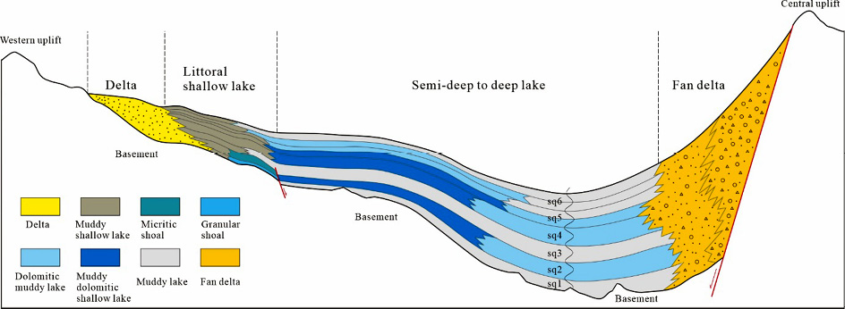
Figure 8 Facies belt distribution model of the Fourth Member in the Leijia area, Western Sag.
4 Discussion
4.1 Reliability and Uncertainty of the Fine Stratigraphic Framework
The core uncertainty controlling regional correlation of the Fourth Member mainly comes from the difficulty in stably picking the top boundary in the sag center: both the top of the Fourth Member and the bottom of the Third Member in this area are deep-water fine-grained sediments with weak lithological and electrical differences, and single-well curve interpretation is prone to interface drift. This study enhances the reproducibility of top boundary correlation by combining “regional marker bed anchoring–well-to-well tracking correction–cyclostratigraphic interface reference” to upgrade interface identification from single-well interpretation to regionally consistent comprehensive discrimination.
In contrast, the lithological and electrical contrast between the bottom boundary of the Fourth Member and the Fangshenpao Formation is clear and can serve as a stable lower boundary condition, providing a reliable benchmark for cyclostratigraphic identification and sequence division.
The eccentricity-scale cyclostratigraphic framework introduces time constraints for fine correlation(Fischer et al. 2004; Schwarzacher 1993). The 405 kyr long eccentricity signal is stable in the study area and is suitable as the main control scale for fourth-order sequence division(Berger 1988; Berger 2021). For short periods, the ~129 kyr signal is more distinct and can establish a traceable cyclostratigraphic sequence among multiple wells(Laskar et al. 2011; Laskar et al. 2004). However, it should be emphasized that the clear response of short periods does not mean that the sedimentary process is controlled by a single cycle(Waltham 2015; Weedon 2003). Its traceability is often the result of the combined action of sedimentation rate, data resolution, and record completeness. For tectonic belts with strong fault activity and rapid changes in sediment supply, short-period cycles may have phase drift or local absence. Therefore, specific correlation still needs to return to marker beds and lithological assemblages for cross-checking to avoid misinterpreting local events as regional cyclostratigraphic interfaces.
4.2 Main Controlling Factors, Sequence Responses, and Geological Significance of the Asymmetric Sedimentary System
The asymmetry of the Fourth Member sedimentary system is mainly controlled by the single-faulted half-graben basin structure of “east-faulted and west-overlapped, steep in the east and gentle in the west” and the sediment source pattern of the Western Sag. The eastern steep slope belt is close to the boundary fault and sediment source area, with strong syn-sedimentary fault activity and large topographic relief. Coarse clastics rapidly enter the lake along stable channels and form a fan-delta system, continuously squeezing deep-water fine-grained sediments laterally. Meanwhile, terrigenous clastic dilution generally limits lacustrine carbonate deposition. The western gentle slope belt is far from the main sediment source with insufficient clastic supply, which is more conducive to the development of shallow lacustrine fine-grained sediments and local carbonate beach bodies. The sag center has deeper water and is dominated by semi-deep to deep-lacustrine fine-grained sediments. Lamination and deformation structures such as convolute bedding and slumping reflect its high sensitivity to lake-level fluctuations and gravity flow events.
On top of this tectonic–sediment source boundary condition, climate–lake-level changes further modulate the rhythm of facies belt migration and lithological assemblages, thereby forming the basic pattern of “strong clastic input in the east / gentle slope fine-grained and local carbonate in the west / deep-water fine-grained sediments in the basin center,” and showing staged responses within the sq1–sq6 sequences(Boulila et al. 2018; Charbonnier et al. 2023): early strong separation controlled by paleogeomorphology and differential subsidence, deep-water expansion and “leveling and filling” during the maximum lake flooding period, and enhanced system progradation and systematic facies belt migration during the regression stage.
The planar distribution results of sedimentary facies provide regional-scale evidence for the above understanding. During sq1–sq2, the lake basin was highly separated, with shallow lacustrine beach facies developed in the western gentle slope belt, semi-deep to deep-lacustrine fine-grained sediments in the basin center, and fan-delta stably developed in the eastern steep slope belt. By sq4, the early uplift-sag bottom form was gradually filled and connectivity enhanced, western beach facies significantly weakened, and the sedimentary system overall transformed to semi-deep to deep-lacustrine fine-grained sediments and transitioned eastward to fan-delta sediments. During sq5–sq6, on the basis of inheriting the previous pattern, the scope and type of deep-water fine-grained microfacies were further adjusted, with calcareous-muddy/dolomitic-muddy lake bottom and muddy lake bottom becoming the main body. Small-scale normal delta systems may appear in the western gentle slope belt, overall reflecting the process of continuous lake basin filling and repeated facies belt adjustment.
Based on the unified constraint of “regional marker beds–time-constrained sequence framework–multi-well facies belt correlation,” a consistent correlation benchmark can be established between different tectonic belts, reducing interface drift and facies belt misjudgment caused by single-well picking(Hays, Imbrie, and Shackleton 1976; Torrence and Compo 1998), and providing a more reliable stratigraphic–sedimentological framework for interpreting the progradation scope of sand bodies in the eastern steep slope belt, the expansion/contraction stages of deep-water fine-grained sediments in the basin center, and the development conditions of beach facies and small deltas in the western gentle slope belt.
5 Conclusions
The lithology and logging response between the bottom boundary of the Fourth Member in the Leijia area and the Fangshenpao Formation differ significantly, with strong regional correlatability. The top of the Fourth Member in the sag center is deep-water fine-grained sediment both above and below, with weak single-well electrical differences, but stable picking and unified correlation can be achieved under the constraint of regional marker beds and well-to-well tracking correction.
Three sets of regional correlation marker beds are developed within the Fourth Member, including a stable carbonate rock layer in the lower part, the “mud neck” layer above the Gaosheng oil layer, and an analcime-bearing argillaceous carbonate rock layer in the middle, providing key anchor points for fine correlation.
Based on cyclostratigraphic identification results from 37 wells, a stable 405 kyr long eccentricity signal can be extracted from the Fourth Member, and relatively clear ~129 kyr short-period responses are identified, thereby establishing a time-constrained fine correlation framework. The Fourth Member is divided into 6 fourth-order sequences (sq1–sq6), subdivided into c1–c12, with a half-cycle c13 added at the top.
The Fourth Member is dominated by lacustrine facies sedimentation. Proximal fan-delta systems are developed in the eastern steep slope belt, delta and shallow-lacustrine deposits are locally developed in the western gentle slope belt, and semi-deep to deep-lacustrine fine-grained sediments dominate in the sag center. Sedimentary facies show staged migration and basin filling characteristics within the sequence framework, overall forming a sedimentary facies model of “strong clastic input in the east / gentle slope fine-grained and local carbonate in the west / deep-water fine-grained sediments in the basin center,” jointly controlled by half-graben asymmetric tectonics and sediment source differences.