

 Current Views: 10523
 Current Downloads: 7507
Research on Art Design
ISSN Print:2789-0716
ISSN Online:2789-0724
Contact Editorial Office


Subscribe to the latest published information from SCISCAN
Spatial Morphological Characteristics of Traditional Tujia Settlements from an Environmental Adaptation Perspective — A Case Study of Pengjiazhai, Xuan’en County


-
Information:
1. Department of Environmental Design, School of Fine Arts, South-Central Minzu University, Wuhan;
2. Department of Architecture, School of Fine Arts, South-Central Minzu University, Wuhan
-
Keywords:
Traditional Tujia settlements; Stilted architecture (Diaojiaolou); Environmental adaptation; Spatial morphology; Pengjiazhai
- Abstract: Traditional Tujia settlements in the Wuling Mountain region have gradually developed spatial forms and organizational patterns featuring stilted architecture (Diaojiaolou) through long-term adaptation to complex mountainous terrain and a hot-summer and cold-winter climate, demonstrating pronounced environmental adaptability. Taking Pengjiazhai in Xuan’en County as a case study, this paper analyzes the spatial morphological characteristics and environmental adaptation strategies of the settlement across four hierarchical levels: settlement siting, street spaces, architectural spaces, and enclosure interfaces. The findings show that, through context-responsive site selection, a hierarchically structured street system, a clearly differentiated primary – secondary spatial organization, and flexible, adjustable enclosure constructions, Pengjiazhai achieves passive regulation of environmental factors such as solar radiation, wind, heat, and humidity. This low-energy, integrated adaptation model offers valuable design insights for context-responsive architectural practices in contemporary urban and rural construction.
- DOI: 10.35534/rad.0201001
- Cite: Xie, M. J., Tian, S., Shao, Z. Y, & Yang, J. J. (2026). Spatial Morphological Characteristics of Traditional Tujia Settlements from an Environmental Adaptation Perspective — A Case Study of Pengjiazhai, Xuan’en County. Research on Art Design, 2(1), 1-13.
1 Introduction
The Earth’s surface is shaped by complex geographic factors — including topography, hydrological systems, and vegetation — whose modulation of energy exchanges driven by solar radiation and the Earth’s rotation gives rise to diverse surface — atmosphere climatic conditions. Through long-term practices of production and daily life, humans have continuously adjusted their relationship with the climatic environment by means of wind avoidance, rain protection, thermal insulation, ventilation, and daylighting. This adaptive process constitutes one of the most fundamental and original motivations for architectural construction (Pan & Zhang, 2023). As integrated responses to specific natural settings and ways of life, traditional vernacular settlements have gradually developed stable, predominantly passive forms at multiple levels, including settlement siting, street spaces, architectural spaces, and enclosure interfaces. By capturing, regulating, and buffering environmental factors such as wind, light, and heat, these settlements have shaped and consolidated distinctive spatial forms and constructional wisdom regionally. Compared with modern green building approaches that rely heavily on technical systems, such experiential strategies are more closely aligned with local climatic and resource conditions, offering valuable insights for exploring low-energy, place-based vernacular architectural models.
Pengjiazhai in Xuan’en County is one of the best-preserved traditional Tujia settlements in southwestern Hubei. Its overall spatial pattern, street network, and Diaojiaolou dwellings exhibit typical characteristics of the Diaojiaolou tradition of this region. Existing studies have mainly approached Pengjiazhai from perspectives such as ethnic culture (Hu & Chen, 2023; Duan et al., 2022), construction techniques (Chen et al., 2024; Zhang, 2012), decorative features (Gu & Lei, 2023), or architectural typologies (Xie, 2024; Zhu, 2020), while systematic analyses of the relationship between settlement spatial form and environmental adaptation remain limited. From the perspective of ecological architecture, this study adopts a multi-scalar and hierarchical analytical framework to examine how the traditional settlement of Pengjiazhai adapts to its natural environment across different spatial scales.
2 Environmental Regulation through Settlement Siting
2.1 Characteristics of Settlement Siting
Pengjiazhai is located in the transitional zone between river valleys and mountainous terrain in the hinterland of the Wuling Mountains. The region is characterized by pronounced topographic relief, a well-developed hydrological network, and a climate dominated by high temperatures, high humidity, and abundant rainfall, where vertical terrain differences exert a significant influence on the local microclimate. The settlement is arranged along the southern slope of Guanyin Mountain and exhibits a predominantly south-facing orientation, forming a basic configuration of backing onto the mountain and facing the water, with buildings aligned along the mountain and adjacent to the river (Figure 1).
A relatively stable spatial relationship is established between the settlement and the Longtan River, providing residential spaces convenient access to water sources and arable land while avoiding direct placement at the lowest point of the valley, thereby reducing potential risks from flooding and mountain torrents (Li, 2022). A continuous and gently sloping belt of farmland is preserved between the settlement and the river, functioning as a forecourt primarily for agricultural production and clearly distinguishing residential areas from productive land. Enclosed jointly by the river valley and surrounding mountains, Pengjiazhai maintains a relatively inward-oriented environment; external access relies on a suspension bridge, which to some extent reduces external disturbances. As a result, the settlement has been able to preserve its traditional spatial morphology in a relatively intact state under limited influence from modern development.
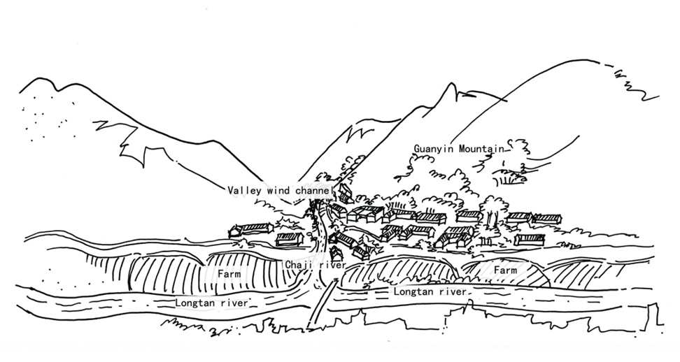
Figure 1 The Environment of Settlement Siting
2.2 Settlement Siting Wisdom under Environmental Adaptation
The combined enclosure of surrounding mountains and the orientation of the river valley shape a local wind environment dominated by valley and mountain breezes. During the daytime, valley winds flow into the settlement along the Longtan River, helping to alleviate the oppressive thermal conditions caused by high humidity in summer. At night, downslope mountain winds facilitate the dissipation of warm and humid air, forming a relatively stable pattern of natural ventilation. Despite partial shading from surrounding mountains, the overall south-oriented layout ensures that primary residential spaces receive sufficient and stable solar access, while also improving the efficiency of solar radiation utilization in winter.
Constrained by both topography and agricultural requirements, limited gently sloping land is prioritized for cultivation, while residential buildings are distributed in linear bands along contour lines. Vertical differences in elevation are used to organize a terraced and hierarchical spatial structure. To adapt to steep slopes, buildings commonly adopt elevated and cantilevered forms, which reduce large-scale earthworks and minimize disturbance to natural slopes, thereby maintaining the continuity of the terrain and the ecological stability of the settlement.
Overall, the siting and spatial layout of Pengjiazhai are not the result of a single determining factor, but rather a comprehensive adaptive strategy shaped by multiple constraints, including mountainous terrain, climatic conditions, hydrological characteristics, and agricultural production needs. By carefully controlling horizontal distance and elevation relationships with the river, the settlement ensures access to water for daily life and production while effectively mitigating flood risks. Through terrain-responsive expansion and low-intervention construction methods, long-term harmony between residential spaces and the natural environment is achieved. Moreover, the passive utilization of natural elements such as prevailing winds and solar exposure contributes to the formation of a relatively comfortable microclimate. This experience-based mode of environmental response reflects the context-sensitive spatial wisdom of traditional Tujia settlements in complex mountainous settings and provides a representative case for understanding environmental adaptation mechanisms and sustainable construction logic in mountain settlements.
3 Environmental Regulation through Street Spaces
3.1 Hierarchy and Spatial Organization of Streets
Influenced by mountainous terrain and the contour-following arrangement of buildings, the street system of Pengjiazhai does not form a regular grid but instead exhibits an irregular, hierarchical structure that unfolds progressively along the slopes. A main street running through the settlement functions as the spatial backbone, while secondary alleys extend along the slope to connect individual residential clusters. The main street is relatively open in scale and accommodates both circulation and public activities, whereas secondary alleys are mostly dead-end spaces that primarily serve residential access and production-related activities. Together, streets at different levels form a rhythmic and articulated spatial sequence.
The circulation system of the settlement is composed of multiple spatial elements, including roads, stone steps, bridges, and courtyards, which not only fulfill transportation functions but are also closely integrated with residents’ daily production and social interactions. Overall, the main street, located near the core of the settlement, serves as the primary spatial framework, linking key public nodes and forming continuous public activity interfaces with courtyard spaces. Secondary alleys extend along the slope, connecting dwellings and courtyards at different elevations; these are typically dead-end spaces serving one or a small number of households and therefore exhibit a higher degree of privacy.
Vertical differences between building levels are resolved through stone steps, enabling the street system to achieve multi-layered spatial organization within a limited horizontal footprint. In addition, the covered bridge across Jicha Gully and the suspension bridge spanning the Longtan River connect internal circulation routes with the external environment. While meeting basic access requirements, these structures also function as important spatial nodes. Courtyards, beyond serving production and domestic purposes, constitute integral components of the street system by providing transitional and buffering spaces between roads and buildings. Overall, the street network of Pengjiazhai was not generated through prior planning, but rather gradually formed through long-term use and residents’ daily movement. Although dead ends and small-scale alleys are relatively dispersed, the system effectively meets everyday mobility and production-transport needs under conditions of limited external access, reflecting a use-oriented logic of spatial organization.
3.2 Street Spaces and Wind Environment Regulation
Street spaces in Pengjiazhai demonstrate a high degree of adaptation to natural conditions in terms of wind environment regulation. The overall orientation of the street network does not strictly follow the direction of the river valley, but instead maintains a certain angle to prevailing valley winds. This configuration channels summer airflow from the valley into the settlement interior, while avoiding the formation of a single-direction, high-velocity wind corridor. In the main street and some narrower alleys, local wind speeds are moderately increased due to spatial constriction effects, which facilitates the dissipation of warm and humid air and alleviates summer thermal discomfort.
Secondary alleys are spatially connected with the stilted ground floors of buildings, forming continuous ventilation paths. The stilted ground level of Diaojiaolou not only minimizes intervention in the terrain but also provides additional ventilation cross-sections for the street system, enabling airflow to circulate between different elevations. Courtyards and eave spaces function as buffers within the street network, preventing direct exposure to strong winds while ensuring basic ventilation requirements. Together, these elements form a multi-layered ventilation structure that allows the settlement to maintain relatively stable natural ventilation under humid and rainy climatic conditions (Figure 2). Through coordinated control of scale, orientation, and spatial linkage, street and alley spaces effectively regulate the wind environment and constitute an indispensable component of the overall microclimatic system of Pengjiazhai.
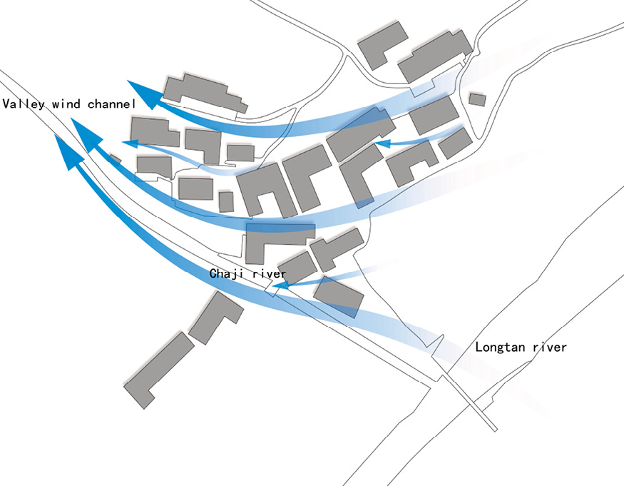
Figure 2 The Wind Environment in Street and Alley Spaces
3.3 Street Spaces and Daylighting Regulation
Under the combined influence of undulating terrain and architectural form, the streets and alleys of Pengjiazhai exhibit pronounced variations in scale and enclosure, resulting in a layered and nuanced daylighting environment. The main street is relatively open in spatial configuration and is often connected to courtyards on a larger scale. With greater width and lower enclosure, it receives ample natural daylight, creating a bright and open public environment suitable for collective activities and everyday social interaction. In contrast, secondary alleys are typically situated between buildings at different elevations. Their smaller spatial scale, together with building overhangs and overlapping eaves, significantly reduces direct solar exposure, resulting in a lighting condition dominated by diffuse light and characterized by overall softness and stability.
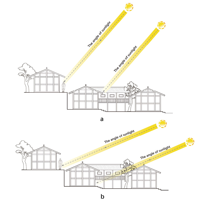
Figure 3 Street Spaces and Daylighting Regulation (a. Summer; b. Winter)
During winter, when the solar altitude angle is relatively low, sunlight can reach building façades and contribute to warming interior spaces. In summer, however, deeply projecting eaves effectively block direct solar radiation. As an important extension of the street system, these eave-covered spaces often form continuous shaded semi-outdoor spaces (referred to locally as “grey spaces”), providing comfortable areas for residents to pause, gather, and interact (Figure 3). Overall, the daylighting gradient composed of “bright main streets, shaded secondary alleys, and transitional grey spaces” helps mitigate thermal loads induced by intense solar radiation under hot and humid climatic conditions, while simultaneously offering differentiated lighting environments for diverse activities. This configuration demonstrates the passive regulation of the light environment through coordinated control of street scale and architectural form.
4 Environmental Regulation through Architectural Space
4.1 Types of Diaojiaolou and Their Formation
As a typical Tujia mountain settlement, Pengjiazhai features residential buildings that are predominantly stilted houses, which have evolved into diverse spatial types over long-term development. Based on existing building forms, they can be categorized into pedestal houses, single-stilted, double-stilted, and two-story stilted types (Hu, 2019) (Figure 4), each exhibiting distinct structural and spatial organization characteristics. This typological differentiation does not stem from aesthetic preference but represents a direct response to variations in slope gradient, site conditions, and construction phases.
In the early stages of the settlement, “pedestal” houses arranged in a linear layout were predominant, built on relatively flat terraces. As the population grew and land became scarce, buildings gradually extended onto the slope by adding stilted structures to the side or beneath existing pedestal houses, forming single-wing or double-wing stilted spaces. This approach expanded the usable area without requiring large-scale earthworks or slope modification.
On steeper terrain segments, buildings further developed into two-story stilted or multi-level stilted forms, stacking spaces vertically to accommodate larger elevation differences. Auxiliary functions are typically placed in the stilted areas, allowing the main residential space to remain relatively intact. Overall, the evolution of Diaojiaolou in Pengjiazhai reflects a construction logic of using elevation as a substitute for leveling, whereby elevated structures replace forced terrain modification. This enables buildings to follow the slope, expand spatial capacity under limited land conditions, and adapt to environmental constraints. Such a strategy not only reduces construction difficulty and earthwork volume but also responds to the humid and rainy climate characteristics of the mountainous environment at the building scale.
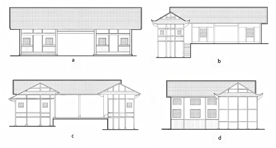
Figure 4 Types of Residential Forms in Pengjiazhai (a. Pedestal house; b. Single-stilted; c. Double-stilted; d. Two-story stilted)
4.2 Spatial Stratification and Functional Organization
Regardless of the specific Diaojiaolou type, buildings are generally divided into three functional levels. The ground-level stilted space is used for storage and livestock keeping, while also providing ventilation, moisture protection, and vertical separation from the living areas above. The main floor typically accommodates the hall (tangwu), bedrooms, and other residential functions, ensuring comfort for villagers. The upper floor consists of attics and terraces used for storage and drying purposes. This vertical functional stratification not only organizes daily life clearly but also separates clean and soiled areas, creating a healthy internal circulation system through functional zoning.
4.2.1 Spatial Design of the Hall
The hall is the brightest and most spacious area within the building, located along the central axis and occupying a fixed, prominent position in the floor plan. Due to the hot and humid mountain climate and its communal functions, the hall is designed to be open. The wooden panels at the front of the hall can be fully opened, and the doors and windows can be removed. This expansive, open space acts as the building’s “breathing hub”, facilitating natural ventilation and passive cooling throughout the house (Figure 5).
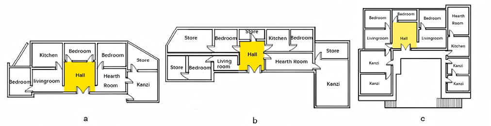
Figure 5 Floor Plan Location of the Hall (Tangwu)
4.2.2 Spatial Design of the Hearth Room
The huotang in Pengjiazhai functions as a multifunctional space for gatherings, entertainment, and dining. Constructed primarily of wooden boards with a wooden joist foundation, the floor of the huotang is slightly elevated compared to other spaces (Figure 6). Narrow wooden lattice windows limit light penetration, which helps maintain thermal comfort during cold and humid winter conditions. The relatively enclosed space, combined with charcoal heating and the heat-retaining capacity of thick walls, establishes a stable and comfortable thermal environment.
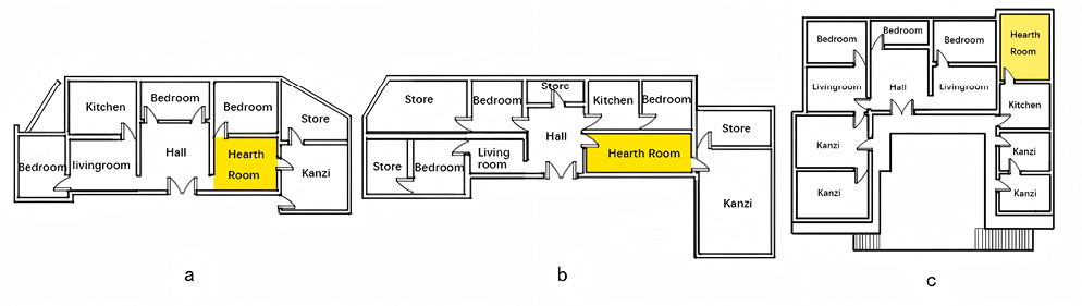
Figure 6 Floor Plan Location of the Hearth Room (Huotang)
4.2.3 Spatial Design of the Kanzi (Bay Projection)
The kanzi is one of the most distinctive features of Tujia Diaojiaolou architecture, referring to the projecting room sections along the front or sides of a building. It consists of a cantilevered floor supported by stilts, vertical balustrades, the roof, and overhanging structures. Through its cantilevered design, the kanzi extends living space outward, making efficient use of challenging terrain such as gullies and steep slopes. Functioning as a semi-enclosed, semi-open climatic buffer, the kanzi moderates internal temperatures relative to both the fully exposed outdoor environment and the core interior spaces. In winter, it acts as a sunlit chamber, preheating incoming air, while in summer, it serves as a heat-dissipation zone, keeping excessive heat out (Figure 7).
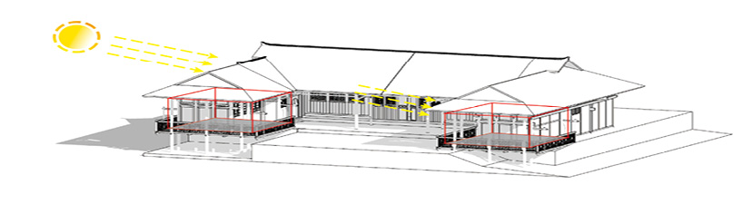
Figure 7 Kanzi as a Climatic Buffer Space
4.3 Ecological Mediation Function of Grey Spaces in Buildings
4.3.1 Ecological Function of the Cantilevered Corridor
The cantilevered corridor (tiaolang) is located beneath the eaves of the kanzi. Projecting from the second floor of the Diaojiaolou, it functions as a transitional space between the enclosed room and the outdoors, expanding usable area over a limited foundation. Serving as a daily activity stage for villagers, the cantilevered corridor accommodates household chores, social interaction, and scenic observation. Its open and elevated spatial character promotes the inflow of high-level natural winds, enhancing internal airflow and dissipating summer heat (Figure 8).
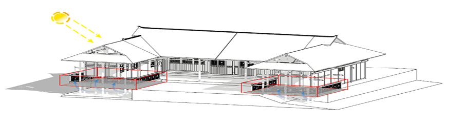
Figure 8 The Cantilevered Corridor as a Climatic Buffer Space
4.3.2 Ecological Function of the Eave Corridor
The eave corridor (yanlang) is situated on the ground floor and functions as both a transitional zone and a climatic buffer. Its deep and extended roof eaves create broad shaded areas that effectively block direct solar radiation from walls and windows in summer and prevent rainwater from entering interior spaces. Acting as a light-and-shadow filter, the eave corridor moderates incoming sunlight, allowing diffuse light to penetrate indoors. Together with the stilted ground floor, the eave corridor forms the lower intake of a vertical ventilation system. Utilizing the “chimney effect”, cool air enters from the base while hot air exits through the upper eaves, continuously enhancing heat dissipation and moisture protection (Figure 9).
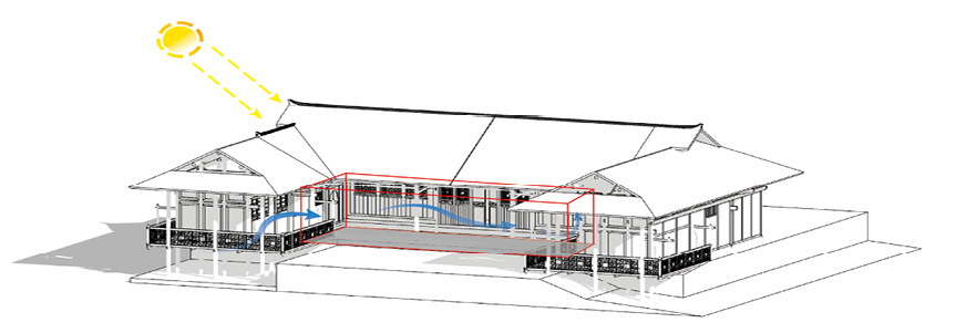
Figure 9 The Eave Corridor as a Climatic Buffer Space
4.3.3 Ecological Function of the Sun Terrace
The Diaojiaolou sun terrace serves as both a drying platform for agricultural products and a solar collector, rather than merely an architectural appendage. In the humid climate of Enshi Prefecture, the terrace provides an open-air space for drying crops, preventing mold and spoilage that would occur if crops were stored indoors for extended periods. This practice creates the distinctive landscape of rooftop grain-drying. Additionally, the sun terrace introduces winter sunlight into the interior, and its open configuration actively maximizes solar exposure.
5 Light – Thermal and Ventilation Regulation through Enclosure Interface
5.1 Adaptive Regulation Mechanisms of Doors and Windows
As key architectural elements distinguishing interior and exterior spaces, doors in Pengjiazhai are predominantly framed panel wooden doors, in which wooden boards are set within timber frames. This structure ensures structural stability while remaining lightweight and economical. When used as the main entrance of the central hall, such doors can be further classified into “true six-panel doors” and “false six-panel doors”.
The true six-panel door consists of six operable leaves arranged as three pairs, often with a decorative pierced lattice window at the center. Some households install glass behind the lattice, while others leave it open to enhance daylighting and ventilation. In contrast, the false six-leaf door allows only the central pair to open, with the side panels fixed as decorative elements, serving primarily for visual articulation and spatial definition.
Windows in Pengjiazhai are categorized into door windows and wall windows according to their placement. Door windows are typically rectangular and located on the main façade of the central hall, while wall windows exhibit more diverse forms and are flexibly arranged in response to façade composition. To adapt to seasonal changes, residents often apply a layer of plastic film to wall windows in winter for thermal insulation and remove it during summer to facilitate ventilation.
Together, these door and window configurations and usage practices constitute a climate-responsive regulation system. In spring and summer, passive ventilation is achieved by harnessing valley winds; in autumn and winter, partial or full closure of openings helps retain indoor heat (Figure 10). This flexible strategy — opening and closing in accordance with seasons and daily cycles — enables indoor temperature and humidity to adapt to climatic variation, maintaining a comfortable thermal environment.
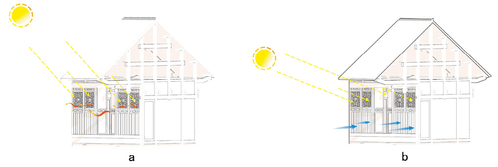
Figure 10 Environmental Regulation of Six-Panel Doors (a. Summer; b. Winter)
5.2 Filtering Mechanism of Wooden Grilles
Exterior walls and window openings of Diaojiaolou commonly incorporate finely spaced wooden grilles. While ensuring ventilation and preventing the direct intrusion of dust and insects, these grilles function as natural filters. Their pierced and carved patterns further allow subtle control over light diffusion and airflow guidance, enhancing overall indoor comfort.
5.3 Thermal Insulation Mechanisms of the Base and Ceiling Interfaces
In Pengjiazhai Diaojiaolou, the building base is elevated on timber columns, lifting the primary living spaces above the ground and maintaining a high degree of permeability. This configuration allows natural winds shaped by mountainous terrain to flow freely beneath the structure, dissipating accumulated ground heat and moisture. As a result, the underfloor space remains relatively dry, reducing thermal pressure on the upper living areas.
Roofs are typically constructed with lightweight materials such as small clay tiles or timber sheathing, with inherent gaps that facilitate ventilation. Combined with steep roof slopes and deep overhanging eaves, the roof primarily serves to block solar radiation. Steep slopes reduce the effective heat-receiving area at midday, while extended eaves limit direct solar exposure of walls, thereby lowering overall heat gain. An air layer between the roof and ceiling forms an insulating buffer that delays heat transfer, allowing the ceiling interface to function as a thermal moderation zone (Figure 11).
The combined strategies of ventilated elevated bases and layered heat dissipation at the ceiling create a bidirectional buffering system, reflecting a mature and sophisticated environmental adaptation wisdom embedded in Pengjiazhai’s Diaojiaolou architecture.
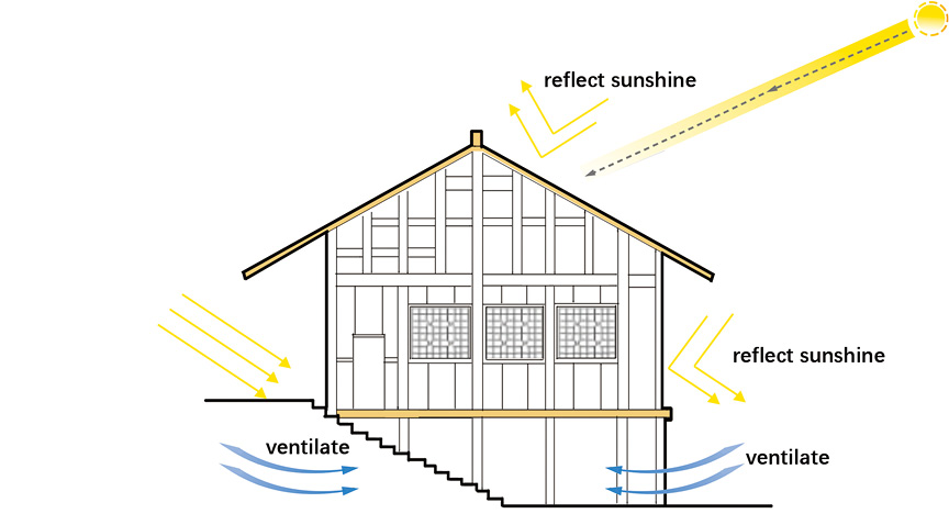
Figure 11 The Thermal Insulation Mechanisms of the Base Interface and the Ceiling Interface
6 Conclusion
Taking Pengjiazhai in Xuan’en County as a representative case, this study systematically examines the spatial morphology and environmental adaptation mechanisms of Tujia traditional settlements across four interrelated scales: settlement siting, street spaces, architectural spaces, and enclosure interfaces. In the context of globalization and technological homogenization, the construction logic embodied in Pengjiazhai — characterized by adapting to local conditions and working with terrain and climate — reveals an architectural ethos deeply rooted in local experience and responsive to specific environmental constraints. This stands in meaningful dialogue with contemporary green building approaches that often prioritize technological accumulation.
The settlement’s multi-layered and integrated environmental response system offers transferable spatial vocabularies and technical prototypes for developing low-intervention, high-performance vernacular-based modern architecture. More broadly, uncovering and interpreting the ecological wisdom embedded in this form of “architecture without architects” contributes to the reconstruction of local identity and environmental ethics in contemporary urban and rural development, bridging cultural continuity and ecological sustainability, and providing living, practice-oriented insights for ecological civilization and regional cultural revitalization.
References
[1] Pan, Y. J., & Zhang, T. (2023). Climatic configuration research on vernacular productive architecture: A case study of the Tujia ethnic “diaojiaolou” grain warehouse in western Hubei. World Architecture, 12, 70−76.
[2] Hu, Q. W., & Chen, S. L. (2023). A study of the architectural characteristics and causes of traditional Tujia dwellings at the Hubei-Chongqing border area: A case study of the eaves space. Central China Architecture, 41(12), 132−138.
[3] Duan, Y. P., Lai, Z. L., Guo, Y. Z., & Zhang, L. (2022). A comparative study of rock dwellings and diaojiaolou in the Wuling Mountains of southwest Hubei from a regional perspective. Decoration, (1), 130−132.
[4] Chen, S. L., Qiao, J., & Li, X. F. (2024). Seeing objects, people, and skills: An anthropological investigation of a Tujia diaojiaolou craftsmen team. Journal of Nanjing University of the Arts (Fine Arts and Design Edition), (6), 1−7, 219.
[5] Zhang, A. W. (2012). Research on the construction techniques, inheritance, and protection of the Tujia ethnic “diaojiaolou” (Unpublished master’s thesis). South-Central Minzu University, Wuhan.
[6] Gu, Y., & Lei, P. T. (2023). The application of Tujia ethnic architectural decorative elements in the interior design of folk hotels in Enshi. Mass Art and Literature, (19), 22−24.
[7] Zhu, F. R. (2020). A study on the spatial layout and construction characteristics of Tujia ethnic diaojiaolou in the Wuling Mountains (Unpublished master’s thesis). Wuhan University of Technology.
[8] Xie, Y. (2024). Research on the architectural gene map of Tujia ethnic diaojiaolou in Enshi (Unpublished master’s thesis). Wuhan University of Science and Technology.
[9] Li, D. H. (2022). Spatial wind environment simulation evaluation and optimization strategies of Tujia ethnic water-side settlements in western Hubei (Unpublished master’s thesis). Huazhong University of Science and Technology, Wuhan.
[10] Hu, B. J. (2019). A study on the architectural form of the Pengjiazhai residential buildings in Enshi Prefecture (Unpublished master’s thesis). Wuhan University of Technology.